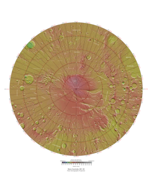
Mare Australe quadrangle
The Mare Australe quadrangle is one of a series of 30 quadrangle maps of Mars used by the United States Geological Survey (USGS) Astrogeology Research Program . The Mare Australe quadrangle is also referred to as MC-30 (Mars Chart-30). [1] The quadrangle covers all the area of Mars south of 65°, including the South polar ice cap , and its surrounding area. The quadrangle's name derives from an older name for a feature that is now called Planum Australe , a large plain surrounding the polar cap. [2] The Mars polar lander crash landed in this region. [3] [4]
Page Revisions
| Year | Metadata | Sections | Top Words | First Paragraph |
| 2018 |
206735 characters 19 sections 114 paragraphs 99 images 298 internal links 34 external links |
11. Craters showing defrosting in spring |
ctx 0.282 reconnaissance 0.217 camera 0.214 hiwish 0.206 hirise 0.200 spiders 0.188 crater 0.187 frost 0.175 defrosting 0.162 orbiter 0.158 ice 0.157 dust 0.153 dark 0.152 enlargement 0.146 eskers 0.141 |
The Mare Australe quadrangle is one of a series of 30 quadrangle maps of Mars used by the United States Geological Survey (USGS) Astrogeology Research Program . The Mare Australe quadrangle is also referred to as MC-30 (Mars Chart-30). [1] The quadrangle covers all the area of Mars south of 65°, including the South polar ice cap , and its surrounding area. The quadrangle's name derives from an older name for a feature that is now called Planum Australe , a large plain surrounding the polar cap. [2] The Mars polar lander crash landed in this region. [3] [4] |
| 2017 |
198054 characters 17 sections 106 paragraphs 94 images 295 internal links 33 external links |
10. Craters showing defrosting in spring |
ctx 0.296 reconnaissance 0.228 camera 0.224 spiders 0.197 crater 0.194 hirise 0.183 hiwish 0.176 defrosting 0.170 orbiter 0.166 dust 0.161 dark 0.160 enlargement 0.153 eskers 0.148 ice 0.148 frost 0.145 |
The Mare Australe quadrangle is one of a series of 30 quadrangle maps of Mars used by the United States Geological Survey (USGS) Astrogeology Research Program . The Mare Australe quadrangle is also referred to as MC-30 (Mars Chart-30). [1] The quadrangle covers all the area of Mars south of 65°, including the South polar ice cap , and its surrounding area. The quadrangle's name derives from an older name for a feature that is now called Planum Australe , a large plain surrounding the polar cap. [2] The Mars polar lander crash landed in this region. [3] [4] |
| 2016 |
162494 characters 16 sections 80 paragraphs 78 images 286 internal links 18 external links |
ctx 0.349 reconnaissance 0.268 camera 0.252 crater 0.226 defrosting 0.200 orbiter 0.190 enlargement 0.180 dark 0.176 frost 0.159 eskers 0.155 dust 0.142 note 0.138 devil 0.133 cheese 0.126 lyell 0.122 |
The Mare Australe quadrangle is one of a series of 30 quadrangle maps of Mars used by the United States Geological Survey (USGS) Astrogeology Research Program . The Mare Australe quadrangle is also referred to as MC-30 (Mars Chart-30). [1] The quadrangle covers all the area of Mars south of 65°, including the South polar ice cap , and its surrounding area. The quadrangle's name derives from an older name for a feature that is now called Planum Australe , a large plain surrounding the polar cap. [2] The Mars polar lander crash landed in this region. [3] [4] |
|
| 2015 |
140446 characters 11 sections 68 paragraphs 69 images 254 internal links 14 external links |
ctx 0.383 reconnaissance 0.294 camera 0.277 crater 0.248 orbiter 0.209 enlargement 0.198 frost 0.175 note 0.152 devil 0.147 cheese 0.138 dark 0.138 lyell 0.134 previous 0.132 image 0.131 dust 0.130 |
The Mare Australe quadrangle is one of a series of 30 quadrangle maps of Mars used by the United States Geological Survey (USGS) Astrogeology Research Program . The Mare Australe quadrangle is also referred to as MC-30 (Mars Chart-30). [1] The quadrangle covers all the area of Mars south of 65°, including the South polar ice cap , and its surrounding area. The quadrangle's name derives from an older name for a feature that is now called Planum Australe , a large plain surrounding the polar cap. [2] |
|
| 2014 |
86955 characters 4 sections 21 paragraphs 26 images 227 internal links 7 external links |
cheese 0.319 swiss 0.281 hirise 0.258 australe 0.222 angustus 0.208 spider 0.205 devil 0.203 inca 0.186 cavi 0.159 burst 0.133 cap 0.133 labyrinthus 0.132 surveyor 0.129 mare 0.128 polygonal 0.117 |
The Mare Australe quadrangle is one of a series of 30 quadrangle maps of Mars used by the United States Geological Survey (USGS) Astrogeology Research Program . The Mare Australe quadrangle is also referred to as MC-30 (Mars Chart-30). [1] The quadrangle covers all the area of Mars south of 65°, including the South polar ice cap , and its surrounding area. The quadrangle's name derives from an older name for a feature that is now called Planum Australe , a large plain surrounding the polar cap. [2] |
|
| 2013 |
86122 characters 4 sections 21 paragraphs 25 images 227 internal links 7 external links |
cheese 0.319 swiss 0.281 hirise 0.258 australe 0.222 angustus 0.208 spider 0.205 devil 0.203 inca 0.186 cavi 0.159 burst 0.133 cap 0.133 labyrinthus 0.132 surveyor 0.129 mare 0.128 polygonal 0.117 |
The Mare Australe quadrangle is one of a series of 30 quadrangle maps of Mars used by the United States Geological Survey (USGS) Astrogeology Research Program . The Mare Australe quadrangle is also referred to as MC-30 (Mars Chart-30). [1] The quadrangle covers all the area of Mars south of 65°, including the South polar ice cap , and its surrounding area. The quadrangle's name derives from an older name for a feature that is now called Planum Australe , a large plain surrounding the polar cap. [2] |
|
| 2012 |
83816 characters 4 sections 21 paragraphs 23 images 227 internal links 7 external links |
cheese 0.319 swiss 0.281 hirise 0.258 australe 0.222 angustus 0.208 spider 0.205 devil 0.203 inca 0.186 cavi 0.159 burst 0.133 cap 0.133 labyrinthus 0.132 surveyor 0.129 mare 0.128 polygonal 0.117 |
The Mare Australe quadrangle is one of a series of 30 quadrangle maps of Mars used by the United States Geological Survey (USGS) Astrogeology Research Program . The Mare Australe quadrangle is also referred to as MC-30 (Mars Chart-30). [1] The quadrangle covers all the area of Mars south of 65°, including the South polar ice cap , and its surrounding area. The quadrangle's name derives from an older name for a feature that is now called Planum Australe , a large plain surrounding the polar cap. [2] |
|
| 2011 |
62058 characters 10 sections 31 paragraphs 18 images 91 internal links 20 external links |
7. Starburst Channels (Spiders) |
cap 0.332 ice 0.237 cheese 0.224 spiders 0.173 swiss 0.165 dust 0.158 australe 0.156 polar 0.149 hirise 0.132 gas 0.131 pole 0.131 inca 0.131 south 0.127 dioxide 0.118 retreat 0.115 |
The Mare Australe quadrangle is one of a series of 30 quadrangle maps of Mars used by the United States Geological Survey (USGS) Astrogeology Research Program . The Mare Australe quadrangle is also referred to as MC-30 (Mars Chart-30). [1] The Mare Australe quadrangle covers all the area of Mars south of 65°. Around the southern ice cap is a surface, called the Dorsa Argentea Formation that may be an old ice-rich deposit. It contains a group of sinuous, branched ridges that resembles eskers that form when streams are under glaciers. [2] The formation often contains pits: two major locations are named Cavi Angusti and Cavi Sisyphi. The pits have steep sides and an irregular shape. They are up to 50 km across and 1 km deep. [3] |
| 2010 |
48145 characters 10 sections 31 paragraphs 18 images 85 internal links 7 external links |
7. Starburst Channels (Spiders) |
cap 0.337 ice 0.240 cheese 0.227 spiders 0.175 swiss 0.167 dust 0.161 australe 0.158 polar 0.151 hirise 0.134 gas 0.133 inca 0.132 south 0.120 retreat 0.116 pole 0.116 pits 0.105 |
The Mare Australe quadrangle is one of a series of 30 quadrangle maps of Mars used by the United States Geological Survey (USGS) Astrogeology Research Program . The Mare Australe quadrangle is also referred to as MC-30 (Mars Chart-30). [1] The Mare Australe quadrangle covers all the area of Mars south of 65°. Around the southern ice cap is a surface, called the Dorsa Argentea Formation that may be an old ice-rich deposit. It contains a group of sinuous, branched ridges that resembles eskers that form when streams are under glaciers. [2] The formation often contains pits: two major locations are named Cavi Angusti and Cavi Sisyphi. The pits have steep sides and an irregular shape. They are up to 50 km across and 1 km deep. [3] |
| 2009 |
37636 characters 10 sections 25 paragraphs 16 images 79 internal links 6 external links |
cheese 0.297 cap 0.248 swiss 0.218 ice 0.206 inca 0.173 retreat 0.152 hirise 0.131 city 0.131 snow 0.131 pole 0.130 devil 0.126 dust 0.126 polar 0.126 south 0.123 walls 0.114 |
Mariner 9 showed a small area located at 82° S and 66° W that looked like the ruins of an ancient city. Mariner 9 team members named it "Inca City." It looked like sand dunes that formed from winds that blew from two different directions, but the dunes were too big. In 2002 the camera on Mars Global Surveyor revealed that Inca City was part of a large circular structure that was 86 km in diameter. So the shape meant that it was probably caused by an asteroid impact which cracked the crust. Later, magma flowed along the cracks. When the magma cooled, hard, erosion resistant walls of rock (dikes) formed. The crater was covered over, then partially exhumed. The hard walls of rock wre left standing as softer surrounding material eroded away. [1] |